(click for interactive version, courtesy of Platial)
Stewart Brand talked about how building learn, and defined a set of what he called shearing layers. The bottom-most layer of his shearing layers is "Site," which states that the site is eternal. That's certainly true, to a point. Dubai's The World is not an eternal site: it's being built right now, and much of San Francisco is on landfill. However, eternal or not, once the boundaries of site are defined, it's very difficult to change them. Many Italian towns, such as Siena, still show the traces of the Roman coliseums that dominated their centers two thousand years ago, even though the coliseums and the buildings all around them, are long gone.
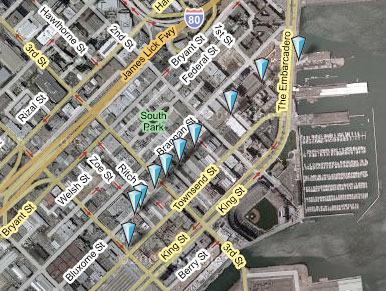
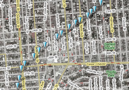
Modern cities have this, too, and they learn at an urban level. I decided to follow up on an observation my friend Jim made some years back. He told me that you could see where the old railroad right-of-way used to pass through his part of the neighborhood we both live in. San Francisco used to be dominated by railroads which, probably much more than the Gold Rush, built the city in the 19th century. However, throughout most of the 20th, these railroads have been systematically dismantled. Generally, they were dismantled after neighborhoods had grown up around them, and as the railroads sold off the land where track used to lay, the pieces they sold were not necessarily in line with the SF street grid. Even through as much as 100 years may have passed since a right-of-way was sold, undoing all the funny shaped pieces of land is difficult and expensive, so developers build in what's available. What you get then, and what's visible from a satellite map, is a picture of the paths which used to snake through San Francisco, defined by connecting the dots of funny-shaped buildings.
I've made two of these Urban Palimpsests, as I'm calling them, using Platial. The first (on the left, above, of the SOMA area of San Francisco, where I used to have an office. The second is of the area that Jim talked about, tracing the path of a big rail spur through much of the Mission.
I've found several other such railroad palimpsests in the city, each of which reminds me how some decisions are imperceptibly permanent and how the most seemingly permanent things are sometimes temporary.


Victor: Good call on the Piazza del Campo. It was the "most famous" example of that idea, and it's good--if unfortunate--to know it's not the site of a forum, but I saw similar patterns in Ivrea, Italy, which was a Roman settlement (looking at the map, http://tinyurl.com/yyd72c, I believe it's where Via Peana curves, but I can't find a good satellite image to verify).
Also, if I understand your point correctly, I agree that cultural "marks" last even longer, potentially, than geographic ones. But only potentially. Some aspects of culture have certainly survived major changes, even ones that have wiped out property lines (I was just reminded of the stability of the Civil Code, i.e. everyday laws, and how Germany--for example--changed governments and governmental systems half a dozen times in the last 100 years, yet they still use the same Civil Code, which is in turn based on Roman Law), but I suspect that's more the exception that the rule. Property lines exist everywhere, and are mostly stable everywhere, which isn't the same for cultural markers.
About the Roman city and the monumental scar, one common belief that does not apply to the Piazza del Campo:
"Siena may have had earlier Etruscan settlements, but it was not a considerable Roman settlement, and the campo does not lie on the site of a Roman forum, as is often casually suggested."
http://en.wikipedia.org/wiki/Piazza_del_Campo
That comment aside, this post reminded me (don't ask me why, it is just a cadavre exquis) about the deconstruction definition of text (in its broader, deconstructionist sense), and how I imagined it the first time I heard (not read) about it.
"In deconstruction, text can be thought of as "dead", in the sense that once the markings are made, the markings remain in suspended animation and do not change in themselves. Thus, what an author says about his text doesn't revive it, and is just another text commenting on the original, along with the commentary of others."
http://en.wikipedia.org/wiki/Deconstruction#Text_and_deconstruction
A personal view: in Urban Design, time and culture are the principal and most relevant variables (perhaps influencers), so as to even define these marks. It can be exemplified through particular counteracts where those layers were erradicated (or at least tried to), as in Barcelona's "Eixample" (in which the Rambla survives nonetheless) or Haussmannian Urban Planning (on Haussmann it has been said that his Paris redesign even destroyed it socially).
Now I'll stop ranting...
Mike Migurski blogged this kind of thing early this year:
http://mike.teczno.com/notes/scar-tissue.html
It reminded me of this example of how the planning process alone can cause a similar phenomenon, even if it's never followed through:
http://www.cbrd.co.uk/histories/m23/
(see the annotated aerial image in particular).
Do you know Jinnai's Tokyo: A Spatial Anthropology? By collecting and analysing old maps, he shows how Tokyo's lots are still now based on land use patterns from its earliest settlement, even through the multiple annihilations of earthquakes, fires, and bombings. Similar idea.
Too awesome for words, Mike. You know I'm a sucker for a good palimpsest.
Oh, totally. You can see in the bottom one, the Mission one, that the track went between Bernal Hill, in the lower righthand corner (you can see the streets start to get wiggly) and [whatever hill divides the Mission and Noe Valley--Liberty Hill, I think?]. Basically, it's the flattest part of the city in the south. I also suspect that the tracks ended up connecting to what's San Jose Ave, which connects to the 280 and goes in the flat part between Chenery Park and Bernal Heights. That's probably not an accident, either: the city probably bought some of the railroad land, and the freeway, when that came through, probably bought a bunch, too, since it was already surveyed and graded.
i wonder what elements in the extant landscapes influenced the decisions of the railroad planners? did they obey only natural terrain, or did they also have awkward shapes to route around?
i think this idea of urban palimpsest has a lot of potential for amazing exploration. great post.